


Every month, the LVMPDSAR Mountain Rescue team participates in two training sessions. One session occurs on a weekday night and the other session occurs on a weekend day. We train often for a number of reasons, but primarily because we thrive to be over prepared for any situation that we are called upon to help with and because just like most things in life, if you don't use it, you lose it.
Because of the technology that is available today, all of our team members carry GPS devices and utilize other battery-powered gadgets to determine location, elevation, slope, weather, and any other type of environmental information that you can think of. All of these devices are extremely accurate and helpful, however, what if our team was put in a situation where all of those luxuries were missing? What would we do if those devices failed to work or if the batteries ran out?
As a result of the worst-case-scenario train of thought, our team went back to the basics in this weekend's training session, put our electronic equipment away, and pulled out our maps & compass. Our scenario was an airplane crash where teams of 5 were picked up by the Huey and inserted to an unspecified location via fast-rope. Each team was given a map, coordinates of the location of the plane crash, and were instructed to bring enough food and water to be able to withstand a day in the 111 degree desert heat.
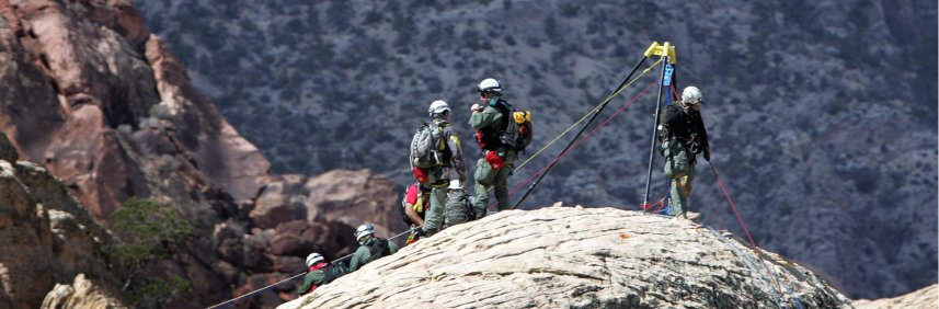
Each team was inserted into a unique location where they were required to decipher their whereabouts using surrounding terrain and map association. From there, each team determined the best route to take in order to get to the location of the plane crash. As each team navigated their way to the crash site, two victims were discovered. Both had sustained injuries from the crash. Here's a picture of the first victim as volunteers began medical and eventually packaged the patient for extraction.
 If you look at the picture above, you will notice that there is a road in the distance. Once both of the patients were located and medically treated, the team extracted the patients, ultimately carrying them to the road that is seen in the picture.
As the team approached the road, the Huey was called in to extract both patients and rescue team members. In the picture below, the Huey has located the team and is looking for the best landing zone (LZ).
.JPG)
.JPG)
In its entirety, the training session took a little over 5 hours to complete. Each team successfully fast roped into an unspecified location, determined their starting point, located the crash site, conducted appropriate medical treatment to each patient, and extracted both patients and team members to wrap up the day. All of this without the use of electronic equipment of any kind!


.JPG)
